
Msak Fm
Type Locality and Naming
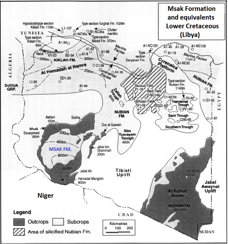
Type section at Jabal Msak escarpment south of Awbari, western Murzuq Basin, Libya (Fig. 1). Klitzsch (1969) named it after Jabal Msak (24°20′N, 26°00′E). Part of the Continental Intercalaire.
References: Klitzsch, 1969; Goudarzi, 1970; Lorenz, 1980, 1987; De Castro et al., 1991; Tekbali, 1994; Hallet, 2002, 2016.
Synonym: Mezak, Mesak or Messak Fm. The spelling was modified to its current form by Hallet (2002) after verifying the official name records of localities in Libya. The name “Ben Ghanima” was also used to describe the Msak formation.
Equivalent(s): The Msak Fm also bare the informal and ambiguous name of “Nubian Formation” or “Nubian Sandstone Formation” (Grès de Nubie) further north in the Murzuq Basin (Hallett, 2002, p. 169).
[Figure 1. The outcrops and subsurface occurrences of the Msak Formation in the Murzuq Basin and its equivalents in the other basin of Libya (Source: Hallet, 2002).]
Lithology and Thickness
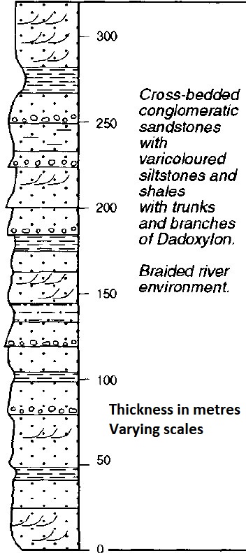
At the Type locality, it comprises continental sandstones and shales, frequently conglomeratic, often massive cross-bedded, and occasionally ferruginous. Two Members have been defined from bottom to top:
- The Jarmah Member (bottom) comprises cross-bedded sandstones, medium- to coarse-grained, and often conglomeratic, interbedded with varicolored siltstones and silty claystone.
- The Awbari Member (top) is composed of massive cross-bedded, pebbly sandstones, which form the top of the Msak escarpment in the Awbari-Jarmah area (Hallett, 2002).
Thickness: 350 m at the Type Locality. On the eastern flank of the Murzuq Basin, the Msak Formation forms the rugged ridge of the Jabal bin Ghanimah (Fig. 1). The thickness of the formation increases from 100 m at Dur al Qussah to 200 m at Jabal bin Ghanimah. Further south, the Msak Formation forms extensive outcrops on the southern flank of the Murzuq Basin in the Jabal Ati and Hamadat Manghini areas, where it reaches 800 m in thickness. The outcrops continue southwards into the Djado Basin of Niger, where thicknesses reach a maximum of 190 m on the “Plateau du Manguéni” and 120 m on the Totomaye Plateau.
[Figure 2. Stratigraphic column of the Msak Formation at the type locality (Source: Hallett, 2002).]
Relationships and Distribution
Lower contact
In the southern and eastern parts of the Murzuq Basin the Msak Formation overlies Precambrian to Paleozoic strata. In contrast, to the west, the Formation overlies with a gradational contact with the Taouratine Fm and Zarzaitine Fm. Contact unconformable.
Upper contact
Overlying Units are marine Cretaceous rocks in Libya. In the Djado Basin of Niger, either the Totomaye Fm, Quaternary rocks or no other deposit.
Regional extent
GeoJSON
Fossils
Plant remains (trunks and branches of Dadoxylon) and a rich spore assemblage.
Age
Depositional setting
The environment of deposition was studied by Lorenz (1980, 1987) and De Castro et al., (1991), who demonstrated extensive tracts of overloaded braided streams flanked by flood-plain siltstones and clay stones. The presence of kaolinite has also deduced evidence of humid, tropical, lateritic weathering as the dominant clay mineral and the abundance of lake and flood deposits. The rocks were deposited in a braided-river environment.
Additional Information